Harrow and Hillingdon Geological Society
High Atacama
Home | Monthly Meetings | Field Trips | Exhibitions | Other Activities | Members Pages | Useful Links
The Geology of the High Atacama, Northern Chile
Dr. Chris J. Carlon Consulting Economic Geologist
(Formerly Vice President – Exploration South America) Anglo-American plc
Chris Carlon has been a practicing mineral exploration geologist for over 35 years and has worked on mines and mineral resource projects in over 40 countries world-wide including leading the teams which discovered the major Sulfatos, San Enrique and Monolito copper deposits in Chile, the Jacaré nickel deposit in Brazil and the Lovisa Zinc deposit in Sweden. He has managed exploration for a wide range of metallic and industrial minerals, in such diverse locations as Russia, Iran and Mongolia, for 5 major mining and exploration companies including BP Minerals, Rio Tinto and Anglo American.
His presentation covered:
- An Introduction to Chilean Geology
- Mineralisation and Earthquakes
- Across the High Atacama – Geological Traverse from Iquique to the Cordillera de los Andes
Chile – An Introduction
Chile is 4,270km (2,647miles) long, extending from 18 oS to 56 oS, and averages 177km (110miles) in width. On a European/African scale, it would stretch from Chad to S. Sweden. Iquique at 20 oS is at the equivalent latitude as southern Algeria; San Pedro de Atacama, at 23 oS, as the Hoggar Massif of the Sahara; Santiago de Chile, at 33 o30’S, as Casablanca, Morocco, or Damascus, Syria; Valdivia, at 30 oS, as Ankara, Turkey; Puerto de Montt and Isla de Chiloe, at 42 oS, as Rome, Italy; and the Torres del Paine, Patagonia, at 51 oS, as Southampton, ie the Patagonian ice cap is at the same latitude as Southampton. With a population of around 16million, 50% of whom live in Santiago and 84% in total in cities, it is a largely empty country
The Straits of Magellan between Tierra del Fuego and the mainland were discovered in 1520. Magellan supposedly used a map by the Chinese who claim to have circumnavigated the globe under the Chinese Admiral Zhou Man in 1421! The first Spanish ships in the Straits of Magellan reportedly discovered Chinese junks. The name of Chile is reportedly derived from the Chinese Chi-Le ( Land of Plenty).
The earliest inhabitants were the Atacamenos and Mapuche people and the Inca invaded as far south as Santiago. The Spanish established their first settlement in February 1541 and the country was liberated from Spain by Bernardo O’Higgins (the son of Don Ambrosio O’Higgins and Isabel Riquelme) in 1818. Chilean Spanish is an admixture of Spanish and Indian words.
In the War of the Pacific 1879-1880 between Chile and Bolivia – Peru, Bolivia lost its coast and Chile expanded north into the Atacama region.
Chile – Geology
Chile lies directly above an oceanic-continental subduction zone with an offshore trench 8,000m (5 miles or 26,250 feet) deep, compared to the deepest ocean trench, the Marianas Trench, off the Phillipines, which is 10,900m (6.8miles; 35,800feet) deep. It has been subject to continuous seismic activity for about 245Ma. The Nazca Plate, which is being subducted, is moving east at 8cm/year and the South America Plate is moving west at 2cm/year.
The principal features of the geology relate to this east-directed subduction, which has been taking place for at least 500my. The western edge of the South American continent has accreted continental blocks, volcanic arcs and back-arc and fore-arc basins. Continuing eastward subduction also gave rise to east and west thrusting, with episodes of compression separated by uplift and extensional tectonics. The Andes have been ‘growing’ since the Cretaceous with fold mountains being intruded by belts of igneous magmatic origin (tectono-magmatic accretion). The latest growth dates from the Miocene and comprises a major magmatic belt (Cordillera de Los Andes). Continuing subduction and extensional tectonics dominate modern Chile.
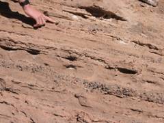
During the Palaeozoic, at 500-350My, a Cambrian-Devonian ocean basin was compressed by the westward movement of the ancient continent of Chilena across the Pacific Ocean. This carried Chilena into Gondawanaland, crushing the Palaeozoic sediments in a continent-to-continent collision in the late Devonian (340My). During the Permo-Triass, a volcanic island arc formed off shore, with a back-arc basin between it and the South American plate. The Pacific continued moving eastwards. In the early Cretaceous, South America split from Africa and started to move west as the Atlantic Ocean opened, slowly crushing the Tarapaca back-arc extensional basin. In the middle Cretaceous (130My), the main Andean orogeny involved collision, accretion of the island arc and back-arc sediments, uplift and erosion, forming the Cordillera Domeyko with sediments from the rising mountains washed eastwards into the San Pedro area to overlie folded Triassic sediments. In the Eocene-Miocene (40-20My), volcanism and plutonism in the Cordillera Domeyko forms the Chuquicamata and other copper deposits. Sediments wash into the basin with evaporitic sediments to produce the Oligo-Miocene Paciencia Group, including the 2,200m thick San Pedro formation.
A west-to-east geological section thus shows the Nazca plate diving under the South American plate in modern deep-slab subduction, the coastal range with recent faulting, infilled faulted pampas and the Cordillera Domeyko (including Chuquicamata). The Salar de Atacama Basin has Permo-Triassic sediments overlain by Tertiary (Eocene-Pliocene) and Recent (Pleistocene to Modern) continental-lacustrine sediments and evaporites and modern volcanics. Then comes the Cordillera de los Andes with Mio-Pliocene (20-4My) volcanics as acid ignimbrites and rhyolites and Pliocene to modern (4-0My) andesitic volcanics.
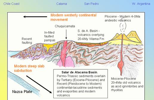
West to east geological section across northern Chile
Except in the extreme south (south of about 48 oS), there is consistently a coastal range, a central depression or basin and the main Andean cordillera. Southern Chile has Coastal cordillera and batholith, the Patagonian ice-cap and the Magallanes Mesozoic turbidite basin. Central Chile has Coastal Cordillera, the Central (agricultural) Valley and the High Andes to 6,959m (22,800ft) at Aconcagua in Argentina. The border with Argentina is a mountain range formed in the Cretaceous, with no volcanoes but an enormous fold mountain sequence, including the continent’s highest peak. The subduction zone here is at a shallower angle than elsewhere so the descending material does not melt but there is a lot of vertical movement (eg the land rose by 1m after the Concepcion earthquake in 2011). Northern Chile, Atacama, has Coastal Cordillera, the Central Depression, Precordillera Ramp and basins, Salars (salt lakes and basins) and the High Andes with Miocene – Recent volcanoes to 6,893m (22,600ft)at Ojos del Salado.
Geology in Modern Chile
There are two main geological phenomena that play a dominant force in modern Chile. These are deeply rooted in the population’s psyche - for two entirely different reasons.
Copper Mining and Mineralisation
Chile has about 40% of the world’s known copper resources and is the world’s largest copper producer with about 6Mt per annum, 38% of annual world production. It is also the world’s 2nd largest Molybdenum producer with around 45,000t, which is produced as a by-product. It has some of the world’s largest and richest porphyry Cu-Mo deposits. Most of this mineralisation occurs at 18-34 oS in northern and central Chile and is spatially and genetically related to Mesozoic and Cenozoic calc-alkaline intrusives. The topography and high aridity create important supergene enrichment.
Chile has 5 main volcano-plutonic arcs:
- Cretaceous, with 4,6M tons Cu;
- Palaeocene, with 56M tons Cu, including the Spence (4M tons) and Cerro Colorado (4M tons) mines;
- Eocene-Oligocene, with over 220M tons Cu, including the Collahuasi (38M tons), Chuquicamata (over 66M tons), La Escondida (over 26M tons), El Salvador (6M tons) and Potrerillos (4M tons) mines;
- Mio-Pliocene, with over 183M tons Cu, including the Los Pelambres (36M tons), Andina-Los Bronces (over 50M tons) and El Teniente (over 76M tons) mines; and
- Pleistocene-Modern, including the Adacollo mine (0.6M tons).
Copper porphyry deposits
The porphyry deposits comprise mineralised multi-phase felsic-andesitic intrusives, which are highly oxidised with medium to high potassium contents and calc-alkaline in nature, i ntruding granodioritic plutons and batholiths and basaltic-rhyolitic volcanics, which are in turn cut by late stage andesitic dyke swarms and plutons and post-mineral diatremes. Structural control is through the Eocene-Oligocene belt and the Domeyko fault zone in the Cordillera Domeyko.
Primary Hypogene Mineralisation is concentrically zoned alteration, which affects host intrusive and country rocks, with alteration zones often superimposed and often a barren core. The main ore is in the potassic (feldspar) and phyllic (mica) alteration zones and Bornite – Chalcopyrite – Pyrite metal zoning is very common (Cu inwards). The porphyry systems are completely permeated with disseminated sulphides and primary stockworks with copper, gold and arsenic. One exploration hole 1km deep was mineralised for the full depth at 1% Cu.
Styles of deposits include vein stockworks and crackle breccias, the A-veins (SiO 2-Cu-Mo) with K alteration, the B-veins (Planar quartz-Cu, K feldspar at depth) and D-veins (quartz-pyrite + Cu with sericite alteration) and disseminated sulphides.
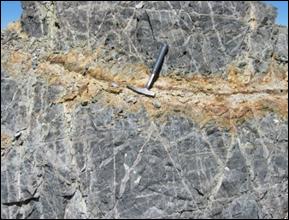
Primary hypogene mineralisation in veins Secondary supergene mineralisation
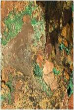
Surface oxidation and leaching give rise to supergene enrichment. Above the water table, oxidation of iron suphides leads to the formation of sulphuric acid, sulphides break down and are soluble, leaving native elements, oxides and oxi-hydroxides, carbonates, sulphates and phosphates. Iron forms limonite, haematite and goethite, copper forms native copper, cuprite, malachite, azurite, chrsocolla, turquoise etc and arsenic forms scorodite. Soluble elements are carried downwards and, below the water table, sulphides re-precipitate as covellite and chalcocite (copper) and violarite (nickel). Thus the surface outcrop is an oxidised gossan with secondary phyllosilicates (silica-limonite-jarosite) above the zone of supergene enrichment and then the original low to high
grade ore of pyrite-bearing sulphides. Mineral targets are copper carbonates and silicates in the oxidised zone, chalcocite in the supergene zone and chalcopyrite, bornite and molybdenite in the primary hypogene zone.
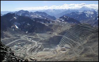
In summary, the porphyry systems comprise large (multi-billion tonne), clustered, focussed, low to medium grade (0.4-1%Cu), vein stockwork, breccia and disseminated Co-(Mo)-(As) deposits. Primary hypogene, hydrothermal sulphide mineralisation is time-constrained (Eocene-Oligocene and Miocene-Pliocene being the main periods). Alteration/mineralisation patterns are reasonably well understood but are often complicated by overprinting and post-mineral intrusion. Surface aridity and uplift have created thick surface oxide leach zones and sub-surface, hidden, medium to high grade supergene sulphide enrichment. This enables the creation of large-tonnage, long-life mining operations, with the mines at about 4,000m above sea level and receiving about 40 feet of snow in the winter.
Exploration is complicated by exploration maturity, competitive land positions, and extensive (and thick) post-mineral cover leading to a variety of mineralisation targets. These include exposed ore bodies with the oxidised zone at surface, hidden ore bodies, with the host rock exposed but the mineralisation hidden (lithocap), and with the deposit hidden under a residual or a non-residual cover and ‘blind’ deposits hidden at depth below non-residual overburden and/or post mineral cover.
Historically, the development of mineral exploration in northern Chile has been in 3 phases:
- Phase 1 (Pre-1960’s), the targets were exposed mineralisation and partly exposed mineralisation
- Phase 2 (1970’s -1990’s) targets were exposed alteration and lithocaps and partly exposed alteration and lithocaps
- Phase 3 (1990’s – Now), the search is for buried alteration and mineralisation under post-mineral surface clastic cover and blind mineralisation under clastics and post-mineralisation ignimbrites and ash-flows.
Earthquakes
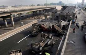
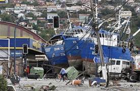
Earthquakes are common in Chile due to the slab-subduction of the Nazca plate beneath the South American plate. Since 1900 there have been about 20 earthquakes with a magnitude greater than 7.5, the 1960 earthquake being the largest at magnitude 9.5 and that of 27 February 2010 being the latest. 525 people were killed and it affected 98% of the population. It was the 6th largest earthquake ever recorded. It occurred 3km offshore and triggered a tsunami and 20,000 aftershocks. The South American Plate moved west by 3m at Concepcion.
The Atacama, northern Chile
The Atacama region of northern Chile extends over 105,000km 2 (40,600miles 2). It is 1000km (600 miles) long x 100km (70miles) wide. It has been an area of hyperaridity for the last 25 M years and some rivers have been dry for 120,000yrs. It does rain (and snow!) in some areas, while in others no rain is recorded, and there are no glaciers even though volcanoes rise to 6,900m (22,600feet). This aridity is due to air inversion, the cold Humbolt current and the Andes blocking westward-moving air. Until 1880, the Atacama was a part of Bolivia but following the Chilean victory over Bolivia and Peru, it was ceded to Chile. Bolivia thus lost its coastal access as well as some of the world’s richest mineral deposits.
Going from west to east, there is a thin coastal zone backed by the Cordillera de la Costa, with recent faulting. Eastward are the infilled faulted pampas of the Pampa del Tamarugal, from which rise the Cordillera Domeyko, with its many copper deposits. The Pre-Cordillera San Pedro De Atacama Basin (Salar de Atacama) comprises Permo-Triassic sediments overlain by Tertiary (Eocene-Pliocene) and Recent (Pleistocene to Modern) continental-lacustrine sediments and evaporites and modern volcanics. To the east, the High Cordillera or ‘Puna’ (Cordillera de los Andes) rises to over 5,500m with Mio-Pliocene 20-4M year-old volcanics as acid ignimbrites and rhyolites and Pliocene - Modern 4-0M year-old andesitic volcanics.
There is a very narrow or non-existent coastal strip. At Iquique, there is a 1,000m high 15M year-old fossil cliff line and the new city is developing on the cliff top. The old city is on an alluvial fan and sand dunes. Offshore is a trench 8,000m (26,000ft) deep with unstable trench walls, which present a high tsunami risk.
The Cordillera de la Costa comprises Mesozoic sediments, volcanics and intrusives with the major Atacama Fault Zone along its eastern border. It has magnetite-haematite iron ores and original 19 th century guano mines.
The Pampa del Tamarugal is a Neotectonic extension belt about 50km (30miles) wide, which has been infilled with Quaternary sediments and fans. It contains major surface sodium nitrate (saltpetre) deposits and is now a zone of about 170 ghost towns which mined these deposits until 1940s
The High Atacama comprises the Cordillera de Domeyko (3,000-4,200m), the Pre-Cordillera Basin (Salar de Atacama) (2,300m) and the High Cordillera (5,200 – 6,000m (about 20,000ft). there are major copper porphyries in the Cordillera de Domeyko, extensive salars in the pre-cordillera basins and explosive ignimbrites, flow domes and stratovolcanoes in the Puna (Cordillera de Los Andes).
The San Pedro de Atacama basin is a fault-controlled extensional rift basin 100km long x 30km wide (62 x 20 miles) below the present volcanic arc. The basin infill is up to 8km (5 miles) thick, with 2km of Triassic red-beds, overlain by 4km of Cretaceous-Paleocene continental clastics (Purilactis Group) with volcanics (from the west) and 2km of Oligo-Miocene Paciencia Group of continental ‘red-beds’ recording initial extension and later compression (folded). They include the San Pedro Formation). In the Miocene and Pliocene – Recent, sediments and pyroclastics were deposited on top (San Bartolo Group).
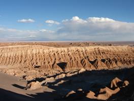
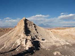
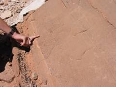
On the western edge of the basin is the Cordillera de la Sal a fault-lifted slice of the Salar de Atacama Basin, exposing the Oligo-Miocene (30-20M years) Paciencia Group sediments. Two units are present – the Tambores Formation (500m of alluvial fan conglomerates, sandstones and gypsum beds) to the west, and the San Pedro Formation, 2,200m thick playa lacustrine red mudstone and evaporite (anhydrite, gypsum and halite).. Strata have been subject to 20-10M year-old folding, thrusting and salt tectonics and are overlain unconformably by Mio-Pliocene (10-2M years) arid continental red-beds plus pyroclastics of the Vilama Formation.
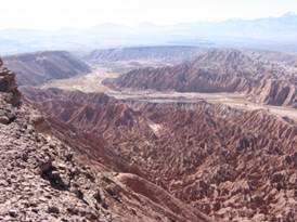
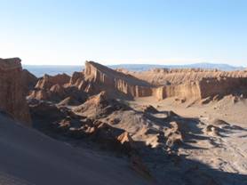
The spectacular scenery of the Cordillera de la Sal displays a variety of geological phenomena including 30-2M year-old rocks, evaporites and clastic rocks, palaeo-arid environments, strong structural deformation and folding along with windblown sand desert scenery and water and wind erosion and deposition.
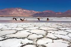
The Salar de Atacama is the largest salt-encrusted lacustrine playa or saline lake in Chile. It is 85km long x 50km wide covering 3,000km 2 (53 x 30 miles; 1,160miles 2). It formed in a hyperarid climate with internal drainage at 2,300m above sea level. Water-soluble saline compounds leached from volcanic and sedimentary rocks are carried into the lake by meteoric water. It is one of over 100 basins in the region and dates in its present form from block-faulting, aridity and volcanism during the Pleistocene. It provides a home for brine shrimp and flamingos.
The Salar is constantly recharged by ground and surface water, principally from the east where annual rainfall is over 50mm per annum. The salar experiences 10-30mm of rainfall per year, a local climate characterised by westerly winds which often exceed 100km/hr, and solar radiation averaging about 6,300,000 cal/m 2/day. This results in high evaporation of 10 litres/m 2/day, which concentrates the sodium, lithium and potassium brines and deposits evaporite minerals. Brine pools are seen below the crust
The salar does not flood but evaporation is equal to recharge, which produces 4 main types of saline crust:
- Silt-sand with halite around the edges
- Gypsum with minor halite
- Halite with sodium chlorite brine at depths of 50-70cm
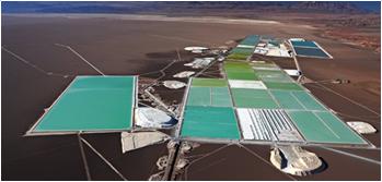
- A salar nucleus with up to 390m of massive halite and an upper porous 20-30m containing a lithium-rich brine.
Tilting in the north has moved the depositional centre to the south. Normally this would be a halite core with peripheral gypsum. The southern halite body contains the world’s largest concentration of lithium brines with nearly 1,800mg/l Li and 28,000mg/l K. These are used to produce lithium carbonate in the world’s largest lithium brine mine operated by Sociedad Quimica y Minera de Chile S.A.
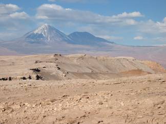
The Cordillera de Los Andes comprises the Altiplano-Puna Late Miocene 10.4 – ca.5 million year old silicic volcanic complex and Plio-Pleistocene (4-1Ma) and late Pleistocene to Modern 10,000year old strato-volcanoes
Late Miocene 10-5M year volcanism was explosive, highly silicic caldera-forming, dacite-rhyolite (acid) coulees and domes and extensive welded ash-flow tuffs, pyroclastics and ignimbrites. These rocks and structures form a large part of the area north and west of San Pedro, covering about 50,000kms 2 of the Altiplano-Puna at altitudes over 4,000m (13,000ft). Quartz, feldspar, biotite, hornblende rocks were erupted at 700-850 oC from a water-rich acid magma.
The stratovolcanoes of Los Andes are early Pliocene to Recent (4-1Ma and less than 10,000years BP) in age. They comprise pyroxene-amphibole andesite, dacite, rhyolite stratovolcanoes in a chain of simple to complex cone and dome structures (10 in the San Pedro area of the Central Andes Volcanic Zone – CAVZ). These are potentially active and dormant volcanoes, with a few historic and recent eruptions. The principal volcanic landforms are andesitic lava flows, tuffs and ash flows, fumaroles, hot springs and geysers (e.g. Puritama and El Tatio).
There is a 22km long north-south belt of complex cones, ash flows and lavas, with 10 post-glacial (less than 10,000 year-old) cones, the highest being Volcan Sairecabur (5,971m; 19,600feet). The summit cone is on the northern edge of an older 4.5km diameter caldera, from which one lava flow runs west and south for 30km to Puritama. There has been no recent activity but extensive fumarolic gas, leaching and sulphur deposits.
Volcan Licancabur is a classically shaped, 10km diameter, stratovolcano rising to 5,916m (19,410feet). It rises 1,500m (4,920feet) above the surrounding area with a 400m crater. The youngest lava flows run up to 6km on the Western flank, sourced from the summit crater, down the 3 o regional slope. These plagioclase, calcium-augite and bronzite, porphyritic pyroxene andesites up to 50-100m thick blocky flows overlie older flows up to 12km long. Cone shape and fresh lavas indicates activity in last 10,000 years
Volcan Lascar is 5,400m (17,720feet) high with a 300m deep crater. It is the most active volcano in the Central Andes, with eruptions in 1986, 1988, 1990, 1993, 2000. There was a major eruption in April 2006, when a gas cloud rose to 8,000m, raining ash on Argentina.
The El Tatio thermal field covers an area of 30km 2 at 4,200 to 4,600m above sea level. Located in a down-faulted graben it hosts a 10km 2 active geothermal field with geysers, springs of water (boiling at 86 oC), sinter terraces and mud volcanoes.
In summary, the Atacama contains:
- Late Miocene to Modern, 10,000 year-old active volcanoes, hot springs and sulphur fumaroles;
- 10.4 to 6.5 million year-old Miocene ignimbrites;
- Triassic to Modern evaporites, (with flamingoes);
- Thrusts faults, folds, unconformities, orogenies and exotic terrains;
- High altitudes, thin air;
- A multi-million year-old desert with 100,000 year-old fossil dry rivers;
- Nitrate ghost towns and world-class lithium brine and copper mines; and
- Earthquakes and tsunamis
In all, - an exciting geological environment!