Harrow and Hillingdon Geological Society
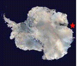
Antarctica
Home | Monthly Meetings | Field Trips | Exhibitions | Other Activities | Members Pages | Useful Links
Reconstructing the history of the Antarctic ice sheet: clues from the past for the future.
Tina van de Flierdt
This presentation covered 4 topics:
- Why should we care about the East Antarctic ice sheet?
- How can a look into the geological past help us to learn about ice sheet behaviour?
- A case study on East Antarctic ice stability during the Pliocene warmth (~3-5 million years ago)
- IODP expedition 318 ( Wilkes Land)
General background
The temperature anomaly for 2000-2009 shows great variability in the amount of warning over the earth. The polar regions of the Arctic Ocean and the surrounding areas of continents and the Antarctic Peninsula have warmed most, up to 2 oC. Glaciers are retreating worldwide and sea level is rising. From 1880-2007 the rate of sea-level rise was 1.7mm per year and in the last 10 years it shows an apparent increase in rate to 3.4mm per year. Is this due to expansion of the oceans as they warm or due to ice melting.
The big unknown is the large ice sheets of Greenland and Antarctica. If the Greenland ice sheet were to melt, it would cause a 7m rise in sea level. Antarctica is 50 times the size of the UK and is the coldest, driest and highest continent, with only about 0.3% being ice-free. If all the ice were to melt, it would lead to a 60m rise in sea level, about 52m for the East Antarctic ice sheet and 3-5m for the West Antarctic ice sheet.
Response of ice sheets to warming
The last 10 years has seen a dramatic increase in observational data and associated scientific understanding of the response of ice sheets to warming. The 2001 IPCC report said that the loss of grounded ice was very unlikely and the Antarctic ice sheet is likely to gain mass. In contrast, the 2007 IPCC report said that loss from ice sheets in Greenland and Antarctica have very likely contributed to sea-level rise over the period 1993-2003 but the dynamics of ice sheets are still considered too complicated to include in predictions of sea-level rise.
Some new data on the Antarctic ice mass balance shows a steady loss of ice mass from 2002-2009 (Velicogna, 2009) and satellite data on the rate of surface elevation change in 2003-2007 (Pritchard and others, 2009) shows that the ice sheet is growing in the interior but melting around its edges. Both Greenland and Antarctica are losing mass and the mass loss is accelerating over the last 18 years. Ice sheets are looking to become the dominant contributor to sea level rise in the forthcoming decades, with up to 0.5m by the end of the century.
Integrated ocean drilling program (IODP)
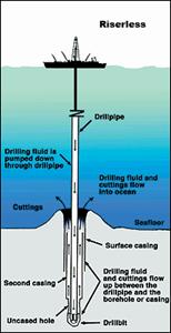
Antarctica was ice-free in the geological past and the drilling of ocean-bed cores can assist in discovering what happened during those times. This is accomplished as part of the Integrated ocean drilling program, an international programme led by the USA and Japan with a strong European input that is scheduled to run from 2004-2013. The IODP is the successor to the Ocean drilling project from 1983-2003, which itself succeeded the Deep-sea drilling project from 1968-1983. Drilling is done from the Joides Resolution, a 143m long drilling ship with a 62m derrick, on board which there are 2 British scientists.
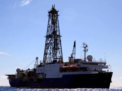
The JOIDES Resolution scientific drilling ship
Sediments from the deep ocean can tell us about the climate of the past 180 million years, including periods when it was warmer than today and periods when there was no ice. They thus give important clues to palaeoclimate and palaeoceanography. Analysis of the global climate over the last 65 million years based on oxygen isotopes (Zachos and others, 2008) indicates that there was a greenhouse world, with temperatures 8-10 oC warmer than today to about 54 million years then a gradual transition to an icehouse world from about 34 million years.
Pliocene warm period
The Pliocene, at 3-5 million years was the most recent period of sustained climatic warmth with a similar continental configuration to that of today. Global sea level was 15-40m higher than today, with the best estimate being 25m, temperatures were 3-4 oC warmer and there was 400ppm CO 2 in the atmosphere (Lisieki & Raymo, 2005) This is about the same level as today, when global average temperature is 14 oC with a CO 2 content of 390ppm. To account for sea-level rise would require the Greenland and West Antarctic ice sheets to have gone plus some of the ice from East Antarctica. The last interglacial was 1 oC warmer and sea level was only about 5m higher and the IPCC forecast for 2100 is for 3 oC warmer than today with sea level 0.5-1.0m higher (Archer & Rahmstorf, 2010).
Pollard & de Conto (2009) suggested that there was no major change in East Antarctic ice sheet volume during the Pliocene warmth, but this cannot reconcile with the 25m change in sea level. In contrast, Hill and others (2007) suggest there was significant reduction during the Pliocene warmth, with a large retreat in northern George V Land, Adelie Land and Wilkes Land.
IODP cores enable the use of the provenance of ice-rafted debris to track where the ice sheet calved icebergs in the past. The cores show times of increased deposition of ice-rafted material of relatively coarse grain size compared to most deep-sea sediments. This material is examined in terms of mineral composition and chemistry to determine provenance.
Antarctica has a diverse geological history, with West Antarctica comprising a young amalgam of terrains of generally Palaeozoic age (500-200 million years) and East Antarctica consisting of very old continental crust of Archaean and Proterozoic age (1-3 billion years).
Isotope fingerprinting at MAGIC (Mass spectrometry and isotope geochemistry at Imperial College, London) uses the decay of potassium ( 40K) to Argon ( 40Ar ) and of Samarium ( 147Sm to neodymium ( 143Nd) to determine the age of the ice-rafted debris. 40Ar/ 39Ar ages give the metamorphic age and Sm/Nd ages give the age of the continental crusts. Marine core-top survey of Ar/Ar ages of individual hornblende grains enable the identification of 8 provenance sectors in Antarctica, namely the Weddell Sea (400-600 million years), Dronning Maud Land (400-600 million years), Prydz Bay (400-600 million years), Wilkes Land (1,100-1,300 million years), Adélie Land (1,500-1,700 million years), George V Land (400-600 million years), the Ross Sea (0-200 and 400-600 million years( and West Antarctica and the Antarctic Peninsula (less than 200 million years).
Ocean drilling site 1165 Prydz Bay
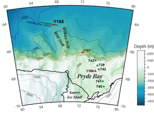
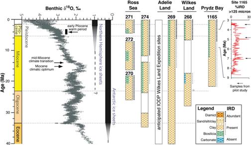
20 million year record of ice-rafted debris from Prydz Bay, ODP Site 1165
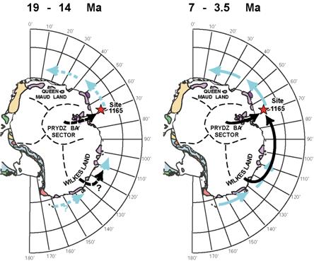
The core from this site gives a 20 million-year record down to the early Miocene of ice-rafted debris at 3.5, 4.8, 7.0, 14, 16 and 19 million years. Potential sources for the debris include the Lambert Glacier, which flows into the Amery Ice Shelf at the head of Prydz Bay and areas to the east, with debris brought by ice-bergs travelling westwards by the near-shore ocean currents. These currents are driven by catabatic winds flowing down from the ice sheet and turned westwards by the earth’s rotation.
Present-day signatures for these sources are 1,500-1,750 million years for the Adélie Coast, 1,100-1,300 million years for Wilkes Land and 500 million years for local Prydz Bay material. Analysis of the cores shows that the 14-19 million-year material is essentially local to Prydz Bay, the 3.5 and 7.8 million-year material is local with a significant proportion from Wilkes Land and the 4.5 million-year material is local and from Adélie Land with some also from Wilkes Land.
Summary of Site 1165 down-core data
Thus ice-rafted debris is locally derived prior to the mid-Miocene (14 million years) but far-travelled grains constitute up to 50% of the 7.0, 4.8 and 3.5 million-year events, suggesting that these represent events of ice-margin destabilisation. The implications of this are that the East Antarctic ice sheet experienced times of major instability during past warm intervals. The most vulnerable parts of the ice sheet are possibly low-lying sub-glacial basins such as the Aurora Basin of Wilkes Land. East Antarctica still shows a near-zero mass balance of -4+/-61Gtonnes per year. Mass loss is observed, however, from a number of glaciers, all of which are marine-based (ie grounded well below sea level) and more prone to instability. A warmer ocean will lead to an increase in the melting of ice shelves.
IODP Expedition 318
This voyage drilled deep-sea sediments off the Wilkes Basin between January and March 2010. After a 9-day voyage from Wellington, New Zealand, 7 holes were drilled before returning to Hobart, Tasmania 2 months later.
The objectives were to:
- determine the timing and nature of the onset of glaciation during the Palaeogene at Wilkes Land;
- obtain a high-resolution record of Antarctic climatic variability during the late Neogene and Quaternary;
- recover an unprecedented ultra-high-resolution Holocene record of climate variability (200 m of sediments.
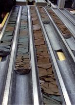
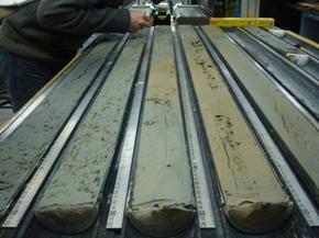
Cores from IODP Expedition 318
Summary
- Sediments close to the Antarctic continent can tell us something about the geology under the ice
- Using isotope geochemistry we can distinguish detailed Antarctic geological sectors
- Provenance knowledge can be used to reconstruct the stability of the ice sheet
- Evidence points to significant instability of the East Antarctic ice sheet during the late Miocene & Pliocene (sub-glacial basins)
- New results from drilling off East Antarctica (in 2010) will start coming out soon