Harrow and Hillingdon Geological Society
Tsunami
Home | Monthly Meetings | Field Trips | Exhibitions | Other Activities | Members Pages | Useful Links
Tsunami – the wave that swallows people
Dr David Brook OBE
WHAT IS A TSUNAMI?
Tsunami is a Japanese word meaning “great harbour wave” or “long wave in a harbour”. It is also known among the native inhabitants of the Andaman Islands in the Indian Ocean as “the wave that swallows people”. Tsunamis are not tidal waves, though often so called in the media.
They are generated by impulsive vertical displacement of the surface of the ocean and spread rapidly in all directions. Most are generated by tectonic events such as fault displacement of the ocean bed during earthquakes but volcanic eruptions, submarine landslides and asteroid impacts could also trigger tsunamis. They are long-period waves, involving an enormous volume of water, and differ significantly from waves generated by winds.
In the open ocean, a tsunami (wavelength 400km, amplitude 0.5-1.0m) will travel at 600-1,000km/hour. As the water shallows, friction slows the wave down and increases its height as later waves begin to catch up. For example, the Indian Ocean tsunami of 26 December 2004 was measured by satellite in the mid-Indian Ocean at 40-50cm in height. By the time it reached Thailand, echo-sounder recordings show wave crests of up to +4.7m with the first wave trough at -1.7m and it was estimated to average 6m as it went ashore.
Tsunamis may cause immense damage to low-lying coastlines, with run-up heights often being 3-4 times the height of the wave itself.
CAUSES OF TSUNAMIS
Large earthquakes that propagate to the sea bed are by far the commonest cause. These are almost entirely restricted to subduction zones where one plate is being dragged down beneath another, such as around the Pacific “ring of fire”, the Indonesian archipelago, the Caribbean and the Mediterranean.
On 1 November 1755, 3 tsunami waves struck Lisbon after a magnitude 8.5 earthquake on the sea floor west of Portugal. 60,000 were killed by the combined effects of the earthquake and tsunamis in Portugal alone. The tsunamis also struck Cadiz, Morocco, Martinique, Barbados and Cuba. The effects were felt in south-west England some 5 hours after the earthquake, with 4 fluxes, with run-ups of up 2.4m, in Mounts Bay, Newlyn, Mousehole, Hayle and Plymouth.
Volcanoes can generate tsunamis directly by explosive eruption, caldera collapse, base surges, pyroclastic flows and lahars. They occur predominantly in the same Pacific “ring of fire”, Indonesia, the Caribbean and the Mediterranean.
In about 1500BC, the explosion and collapse of the island of Thera (Santorini) in the Aegean Sea destroyed the island, caused a tsunami that may have led to the decline of the Minoan civilisation on Crete and may be the source of the legend of Atlantis.
In 1883, the explosion and collapse of the island of Krakatau, between Java and Sumatra resulted in tsunamis which killed 36,000. At least 4 main waves had run-ups of 30-40m on steep coastlines with waves in flat-lying areas going up to 8km inland. Until December 2004, this was the worst recorded tsunami.
Landslides involving rapid transport of a fragmented mass of rock material can be of sufficient size to generate tsunamis in lakes or the sea.
In 1963, a large landslide failed catastrophically and slid into the lake behind the Vaiont dam in Switzerland. It displaced about 50% of the water in the lake creating a tsunami-like wave 200-300m high that raced down the valley towards and over the dam into the valley below. At a height of about 70m the flood destroyed everything in its path and killed over 2000 people. Somehow the dam managed to withstand the giant wave crashing over the top of it and parts of it are still standing today.
About 7,200 years ago, a massive undersea landslide affecting 90,000km2 and involving 3,500km3 of material – the Støregga slide – caused a tsunami which inundated the coasts of Norway and Scotland. Tsunami deposits resulted all along the Norway coast, in the Faeroe Islands, Iceland and Scotland. Studies of this very prominent sand layer suggest minimum run-ups in eastern Scotland of 4-6m above the contemporary high-water mark with 10-20m run-ups in Norway, 10m in the Faeroe Islands and 20m in inlets in the Shetland Islands.
Impacts of extra-terrestrial objects (meteorites, asteroids, comets) in the oceans would generate tsunamis, possibly on unforeseen scales. However, there are no known historical tsunamis generated by extra-terrestrial impact.
In the geological record, a number of impact structures are associated with giant tsunami deposits. For example deposits from the tsunami generated by the Chixculub impact at the end of the Cretaceous period (65M years ago) are found on the margins of contemporary seas as far away as north Texas, over 1,500km away.
Human activity can also lead to tsunamis, usually by inducing landslides but also by explosions. At Nice airport, a runway extension that was being constructed on reclaimed land collapsed as a submarine landslide. A tsunami up to 3m high caused damage along 30km of the French Riviera and several deaths.
An ammunition ship carrying explosives equivalent to 2,900 tons of TNT blew up in the harbour at Halifax, Nova Scotia on 6 December 1917, destroying much of the town and generating a tsunami which caused significant damage and a number of deaths outside the blast zone
THE INDIAN OCEAN TSUNAMI OF 26 DECEMBER 2004.
At 0800 local time on 26 December 2004, a magnitude 9+ earthquake off the island of Sumatra in Indonesia generated a tsunami which hit Sumatra within less than 30 minutes, Thailand, Malaysia and the Andaman and Nicobar Islands after about an hour, Sri Lanka and South India in 2 hours, the Maldives in 3.5 hours and the African coast of Somalia and Kenya in 7.5 hours. In the open ocean it travelled at a speed of 200m/s (about 700kph).
The triggering earthquake occurred over a 400km long area of the subduction zone where the Indo-Australian plate is being consumed beneath the Asian plate. It propagated up to the sea floor and displaced the sea bed by up to 15-20m.
At Banda Aceh, 200km from the epicentre, the wave height averaged 5m (maximum 10m) and at Meulabok, just 100km from the epicentre, run-up heights were up to 30m. Wave heights averaged 6m in Thailand (maximum 11m), 4.5m in Sri Lanka with peaks of 10m, about 4m in the Maldives and 1.2m in Somalia. By the time it reached the far shores of the Atlantic and Pacific Oceans (in about 30 hours), coastal gauge amplitudes were less than 0.5m and generally less than 0.2m. Wave velocities onshore, estimated from video footage at 2 sites, were3-4m/s and 6-8m/s.
The tsunami caused 290,332 deaths. It was the worst recorded tsunami, though there have been 2 worse earthquakes, 2 worse floods and 1 worse cyclone in terms of loss of life. It caused damage in 12 countries around the Indian Ocean, killing people from over 50 nations.
This tsunami devastated the Indonesian province of Aceh, particularly its capital Banda Aceh, with inundation up to 7-10km inland and almost total devastation in the first 2.5km. In Sri Lanka, inundation was up to 1km inland but generally about 400m. Recovery costs for Thailand alone are estimated at $1B with those for Sri Lanka at $2B overall. It caused significant changes to the coastal geography of Aceh province in Indonesia.
HISTORICAL RECORD OF TSUNAMIS
Tsunamis have been reported since ancient times, one of the first known being off the coast of Syria in 2000BC. Since 1900, most tsunamis have been generated off the coasts of Japan, Peru and Chile. Over 1,000 tsunamis have been reported in the last century, 13.5% of which have caused significant damage and loss of life. In the 1990s, 82 tsunamis were reported with the loss of over 4,000 lives. Major tsunamis occur in the Pacific Ocean about once a decade. Because of its central location, Hawaii has experienced tsunamis generated in all parts of the Pacific. The Mediterranean and Caribbean Seas have histories of locally destructive tsunamis but only a few have been generated in the Atlantic and Indian Oceans. Britain has been affected by tsunamis caused by landsliding off Norway 8,000 years ago (east coast of Scotland) and by the Lisbon earthquake of 1655 (Cornish coast).
TSUNAMI WARNING SYSTEMS
In 2006, the Pacific tsunami warning centre was in operation plus national centres in Japan, French Polynesia, Chile, Russia and the United States. Warning centres were in the developing stage in Australia, Korea, Central America, Colombia, Peru and the Caribbean and were planned in the Indian Ocean (India, Indonesia, Thailand).
The principal cause of tsunamis are shallow, large-magnitude earthquakes offshore which cause vertical sea-floor movement. Tsunami warning systems, therefore need to:
• detect the earthquake and determine its hypocentral location and magnitude;
• evaluate if it is tsunamigenic;
• model the amplitude and arrival times of the tsunami;
• confirm and track the tsunami wave; and
• issue warnings.
Currently, worldwide location of potentially tsunamigenic earthquakes is possible within minutes of their occurrence but magnitude determination takes longer (1 hour). Determination of source mechanism and slip-distortion is feasible, allowing a warning to be issued but not confirmed. This requires deep-sea pressure sensors and tide-gauge instruments with links to one centre in real time.
Effective operation of tsunami warning systems requires improved infrastructure, improved regional co-operation, regional or national centres, scientific studies on sources, public and higher education and the implementation of systems to issue and respond to warnings.
The Pacific Tsunami Warning Centre (PTWC), Hawaii
The Pacific Tsunami Warning Centre (PTWC) is operated by the US National Oceanographic and Atmospheric Administration for the Pacific Ocean as a whole and more locally for the West coast/Alaska. It was established in 1946 following the Aleutian Islands earthquake of 1 April 1946. It relies on seismic monitoring to detect the location and size of earthquakes with sea-level monitoring by deep-ocean buoy systems as well as coastal tide gauges.
Initially, predictions issued on the basis of earthquake data alone led to a false-alarm rate of about 75%. Seismic monitoring still plays a primary role, especially for local tsunamis where the lead time from the earthquake to tsunami arrival may be only tens of minutes. Communities must be tsunami-ready, with an emergency operations centre, a means of disseminating warnings (sirens or local media), a tsunami hazard plan and a community-awareness programme.
The seismic monitoring network around the Pacific Ocean is complemented by over 100 coastal tide-gauges, which confirm the tsunami threat and arrival time. To better track the development of regional tsunamis, NOAA deploys 6 DART (Deep-ocean assessment and reporting of tsunamis) systems in the Pacific. A bottom-mounted pressure recorder capable of detecting sea-level changes of 1cm in 6,000m of water is linked by an acoustic modem to a floating buoy that acts as a transmitter to the GOES satellite telemetry system. Each DART system costs $250,000 to buy and $125,000 per year to maintain. System life is about 1 year for the surface buoy and 2 years for the pressure recorder.
Established for 60 years, the Pacific tsunami warning system remains an evolving entity. For local tsunamis when a full emergency response may not be possible, the system has 2 key elements:
• An education programme for emergency planners on tsunami risk, early warning indicators, methods to establish effective emergency communications systems and evacuation procedures that can be implemented rapidly. Thus, decision-making and responsibility for the response to tsunami alerts is devolved to the local authorities;
• The operational service provided by the West Coast/Alaska and Pacific Tsunami Warning Centres in issuing warnings (destructive tsunami imminent), watches (destructive tsunami alert) and advisories (information for non-threatened areas) with updates at least hourly.
TSUNAMIS IN THE PACIFIC OCEAN
As the most earthquake- and volcano-prone area in the world, the Pacific Ocean suffers many tsunamis, both local and trans-oceanic. Indonesia, for example, has had over 40 tsunamis in historical times.
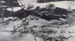
Tsunami Generated by Earthquake of April I, 1946, Aleutian Islands, Alaska
Scotch Cap lighthouse on Unimak Island in the Aleutian Islands was located 9.8m above sea level. It was destroyed, killing all 5 occupants, by a tsunami caused by a magnitude 7.3 earthquake on 1 April 1946. The waves deposited debris as high as 35m above the sea.
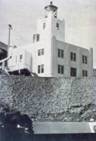 |
Scotch Cap lighthouse before the tsunami Photograph Credit: U.S. Coast Guard (Sorry, no larger images available on this page) |
 |
Scotch Cap lighthouse after the tsunami Photograph Credit: U.S. Coast Guard |
Although it caused little damage in Alaska, this tsunami was one of the most destructive ever to reach the Hawaiian Islands, about 3,800 km from the generating area, killing 159 people and causing $26M property damage (in 1946 dollars). The maximum rise of water was almost 8 m in Hilo and as much as 12 m in other areas on the island of Hawaii.
 |
Photograph Credit: NOAA/EDIS |
 |
Photograph Credit: Mrs. Harry A. Simrns, Sr. |
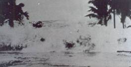
Tsunami Generated by Earthquake of May 22, 1960, Coast of Chile
The tsunami following the magnitude 8.6 Chilean earthquake of 22 May 1960 caused 200 deaths on Isla Chiloe. The inhabitants had taken to small boats to escape the shaking and the trough of the tsunami arrived 10-15 minutes after the earthquake. When the sea returned all the boats were lost. Total property damage from the earthquake and tsunami in Chile was $417M (in 1960 dollars) and over 1,000 people were killed, most of them by the tsunami.
This tsunami affected the whole of the Pacific basin, including causing 61 deaths and $23M property damage in Hilo, Hawaii, 10,000km and 15 hours from the generating area. Parking meters were bent by the force of the debris-filled waves. 8 hours later waves 6m high hit the coast of Japan and killed 180 people.
 |
Photograph Credit: U.S. Navy. |
 |
Photograph Credit: U.S. Geological Survey. |
Tsunami Generated by Earthquake of March 27, 1964, Prince William Sound, Alaska
The power of tsunamis is illustrated by a 2”x4” (50x100mm) plank being driven through a truck tyre in Whittier, Alaska, following the magnitude 8.5 Prince William Sound earthquake of 28 March 1964. Whittier incurred $10M property damage and lost 13 people from a population of 70. One of the waves reached a height of 31.7m above low tide.
JAPAN
Japan suffers tsunamis from both local earthquakes and from trans-Pacific events.
On 26 May 1983, a magnitude 7.7 earthquake hit Akita City on Honshu. The resulting tsunami swept 43 children and 6 adults out to sea on the Oga peninsula. Press reports that day reported 1 dead, 13 missing and 10 seriously injured. 700 boats and 59 houses were destroyed for a total of $800 million in property damage in Japan (1983 dollars). 104 people were drowned in Japan and 3 in Korea.
TSUNAMI AND STORM SURGE MITIGATION IN JAPAN (from a presentation by Yoshiaki Kawata, Research Center for Disaster Reduction Systems, DPRI, Kyoto University)
On 21 December 1946, a tsunami caused by the magnitude 8.0 Nankai earthquake caused major damage in Tanabe and Shingu City burnt down after the tsunami. Wave heights ranged up to 5.5m. Loss of life (in this and other Japanese tsunamis) generally occurs at heights over 2m. Arrival times on southern Honshu for locally generated tsunamis range from less than 10 minutes at Susami to less than 1 hour at Misakicyo.
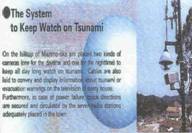
Tsunami counter-measures in Asakawa include both structural and non-structural measures. Structural measures include:
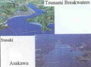
• tsunami breakwaters, eg at Susaki and Asakawa;
• solar-powered streetlights and refuge signs installed along evacuation routes – the solar powered battery lasts for 8 hours;
• sea-level observation with 2 cameras, one for day-time and one for night-time; and
• tsunami stations (operation centre), including cables laid to convey and display information or evacuation warnings on the television of every house.
Non-structural measures include:
• early warning systems (3 minutes after earthquake) by Japanese Weather Service;
• early evacuation issued by Town Headman and radio stations;
• refuge sites; and
• human precautions.
 |
All Slide credits Yoshiaki Kawata, Research Center for Disaster Reduction Systems, DPRI, Kyoto University |
 |
|
 |
|
 |
|
 |
|
 |
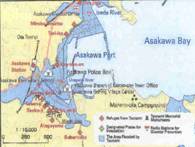
Hazard mapping in Asakawa has identified the area likely to be inundated by tsunamis (or storm surges) and designated places for evacuation and refuges. There are 15 designated refuges and 11 roads for evacuation. However, it is over 50 years since the last tsunami and survivors are becoming fewer. Public memory of the hazard is thus receding. The plan is to establish a self-defence network to awaken and keep alive public consciousness of disaster prevention.
A sub-textbook for elementary schools – Shira-No-Naita Umi (Shiro crying over the sea, which drowned its keepers) – is given to all new pupils to develop their consciousness of disaster prevention. In 1999, a dramatised version of this story was performed in the 9th Japan Summit for Tsunami Disaster Prevention at Kainan-cho.
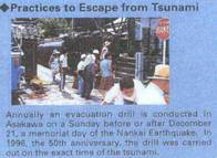
Annual emergency practices are held in Asakawa City, which was devastated by the 1946 tsunami, on or near the anniversary of the tsunami. Throughout Japan regular earthquake drills are held in schools and offices etc.
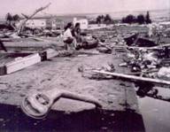
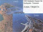
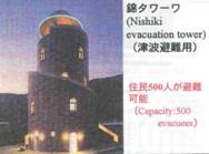
Following the Hokkaido Nansei-Oki earthquake tsunamis in 1993, the town of Aonae on Okujiri Island was devastated. It has since been rebuilt with tsunami breakwaters, raised structures in the port area and evacuation towers.
 |
All Slide credits Yoshiaki Kawata, Research Center for Disaster Reduction Systems, DPRI, Kyoto University |
 |
|
 |
The Japanese Weather Service has operated a local tsunami warning system since 1952. As well as seismic monitoring to detect potential tsunami-generating earthquakes, this includes 80 sea-level sensors capable of giving warnings in 5 minutes.
THE THREAT POSED BY TSUNAMI TO THE UNITED KINGDOM
In historical times, the 1755 Lisbon earthquake generated a tsunami that struck south-west England. There is firm geological evidence of a tsunami impacting Scotland and north-east England 8,200 years ago following a submarine landslide offshore Norway. The possibility of significant future events cannot be dismissed. Defra Flood Management Division, therefore commissioned a study by the British Geological Survey (with HR Wallingford, the Meteorological Office and Proudman Oceanographic Laboratory) to make a preliminary assessment of the threat posed by tsunami to the UK.
Possible sources were reviewed and the potential threat was assessed in terms of the likelihood of a tsunami being generated that would impact on the UK and probable limits on its size. Evidence for past tsunami events affecting the UK was also examined. For the most likely sources, numerical modelling of wave propagation allows the prediction of travel times, the increased height of sea level and the nearshore regions that would be affected.
Possible source zones
Possible source zones for tsunamis to impact on the UK include:
1. UK coastal waters – UK seismicity is generally minor but the North Sea graben systems represent a failed Cenozoic rift on which larger magnitude tsunamigenic earthquakes are credible, though unlikely (annual probability less than 1 in 10,000).
2. NW European continental slope – The NW European continental margins are passive margins not subject to seismicity caused by relative plate movements. However, passive margins can be a source of anomalously large earthquakes, which might be big enough to trigger a tsunami directly or by triggering a large submarine slide. Tsunamigenic earthquakes in the Western Celtic Sea or Rockall Trough or large submarine slides offshore Norway or NW Scotland are credible but unlikely.
3. Plate boundary area west of Gibraltar –Tsunamis following large earthquakes in this area have been recorded in 1755, 1941, 1969 1975. A tsunami reaching the UK from the Azores – Gibraltar region is possible but is unlikely to be worse than the 1755 event.
4. Canary Islands – These are a chain of ocean island volcanoes, which show evidence for large landslides on their flanks. It has been suggested that collapse of La Cumbre Vieja on La Palma could trigger a mega-tsunamis that would still be tens of metres high even after crossing the ocean and would devastate the North Atlantic coastlines of America and Europe. However, studies of offshore landslide deposits suggest that they are multiple events occurring over several days rather than instantaneous collapse, possibly leading to a series of discrete smaller-scale tsunamis.
5. Mid-Atlantic Ridge – It has been suggested that the mid-Atlantic ridge could be a source for tsunamis triggered by volcanism, earthquakes or slope failure near the ridge but no tsunami has been recognised from a mid-ocean ridge event anywhere in the world.
6. Eastern North American continental slope – Like the north-west European continental slope, that of eastern North America is a passive margin but it differs in one significant respect. The Grand Banks earthquake of 1929 triggered a large submarine slide and the resulting tsunami damaged parts of Newfoundland and Nova Scotia and killed 28 people. It arrived in Portugal 6 hours 18 minutes later but went unremarked in the UK. Landslide-triggered tsunamis such as this tend to be purely local and there is little likelihood of any effect on the UK.
7. Caribbean Sea – This is the one place in the North Atlantic where subduction tectonics can be observed and tsunamis are common in the Caribbean. The tsunami from the 1946 M 8.1 Dominican Republic earthquake was recorded in New Jersey at no great amplitude but no Caribbean tsunami has ever been reported as detected in Europe.
CONCLUSIONS
A North Sea event is theoretically possible but unlikely. It would be a relatively small event and there is no evidence for any precedent.
There is geological and some weak historical evidence for tsunamis generated from the NW European continental slope. This is probably the most significant tsunami threat to the UK.
Historical observations of the 1755 Lisbon earthquake and tsunami probably represent the worst-case event from the plate boundary area west of Gibraltar.
Evidence suggests slope failures on the flanks of the Canary Islands volcanoes are unconsolidated when they occur and thus are likely to create tsunamis of only local concern.
The mid-Atlantic ridge has effectively zero risk to the UK and any tsunamis originating on the eastern North American continental slope or the Caribbean will have insignificant effects in the UK.