Harrow and Hillingdon Geological Society
Geophysics in Archaeology
Home | Monthly Meetings | Field Trips | Exhibitions | Other Activities | Members Pages | Useful Links
Application of geophysics and geology to Hebridean archaeology
Reverend Dr Timothy Astin
This presentation covered the assistance given by geology and geophysics to studies by Professor Steven Mithen of the first hunter-gatherers in the Hebrides and by a PhD student, Darko Maricevic, into the late Neolithic/early Bronze Age introduction of farming.
The study area was the Hebridean islands of Mull, Coll and Tiree. Tiree is very flat, with 3 prominent hills surrounded by low sand dunes and wave-cut platforms. Coll is much more hilly, with some flat areas in the south-west. The studies were generally concerned with land over 10m above sea level.
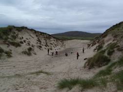
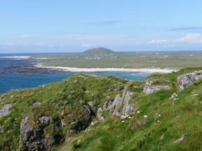 Topography of Tiree
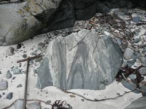 Dalradian gneisses
Archaeology on the islands includes stone circles, standing stones and one or two possible chambers of Neolithic age and field systems, barrows and pottery of late Bronze Age. There is also evidence of roundhouses, hut circles and islet and sand-hill settlements.
A lot of the early settlements were tied to coastlines, where there was a source of food and raw materials. The environmental context of the coastline is thus important to the archaeology. The coastline has moved up and down due to global sea-level changes and due to isostatic rebound since the last ice age. Studies from Northern Ireland show that the late glacial raised beach is at +20-30m at 20,000BP (years before present), then apparent sea level fell to -20m during the decline Scottish Devensian ice sheet at 20-15,000BP and the Younger Dryas ( Loch Lomond re-advance) at 13-12000BP. It then rose to +5-10m at 6-7,000BP and fell again to the current sea level.
Hunter-gatherers arrived in 2 phases, firstly at about 13,500BP then after the Younger Dryas. The first farms developed at about 4-,3000BP. Other notable events include the Stǿregga tsunami affecting the east coast of Scotland, the Orkneys and Shetlands at 7,900BP. The first well dated settlements in Harris are at 7,000-6,600BP.
Late-glacial shorelines occur on Mull at about +30m, on Coll and Tiree at +22-+9m sloping westwards, in Northern Ireland at +20m and in south-west Scotland at +30m. At Port Ballintrae, Northern Ireland, marine sediments overlie till at +20m, showing that the shoreline post-dated deglaciation. In south-west Mull, the basal organic post-glacial sediments have been dated at 15,600BP, while Northern Ireland was ice-free by 14,000BP. The Loch Lomond re-advance has been dated at 12,900-11,500BP on the basis of a date of 11,700BP for the earliest post-glacial sediments.
The late Holocene (6,900-5,700BP) high shoreline is at +5-6m on Skye, +5-8m at Kentra-Arisaig, about +5m in Northern Ireland, +10m in south-west Scotland and +4.5m in Islay. It is predicted to occur in Tiree at 0-+10m, a significantly lower elevation than in Mull.
Mesolithic coastal occupation at Croig Farm, northern Mull
At Croig Farm there is a concentration of flints in a field and excavation was begun, though soon flooded as a result of a natural spring on the site. Ground radar was used to identify the beach surface beneath the peat. Beach cobbles were measured and the sediments sieved to find flints, all of which were imported onto the beach. 5,000 pieces of flint were found. A spring-fed peat occurs beneath the raised beach (on gentle slopes) and there is a peaty deposit on top of the raised beach. The peats have been dated to 7,200 and 4,000BP. There is no flint in situ, it has all been eroded by the sea and been deposited on the raised beach. Thus the settlement was older than the beach.
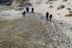
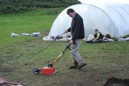 Using ground radar
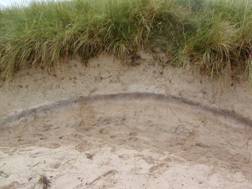
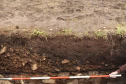 Peats bracket the raised beach
Timing of coastal sand-dune accumulations
The initial focus of archaeological investigation was on standing monuments but it is now increasingly looking for evidence of farming activities such as field systems. The timing of coastal sand dune accumulation is critical in this evaluation. Sand dunes have been dated by optical luminescence techniques in Northern Ireland, which shows there were 3 broad periods when the dunes were mobile:
- the recent historical period (little ice age) to 1950 (when the planting of marram grass stabilised the dunes);
- 4,000-2,500BP in the late Neolithic climatic deterioration (3,900-3,500BP) and widespread in the late Bronze Age-early Iron Age; and
- possibly 7-6,000BP linked to the post-glacial sea-level high.
The same pattern is widespread in western Europe, including the Outer Hebrides, Northumberland, Norfolk and southern Spain. The question arises as to whether the mobilisation of the dunes was driven by the climate or by human activity, eg the transition from hunter-gatherer to farming. Sand-blowing re-started in the late Neolithic-early Bronze Age in Orkney.
Archaeological sites in the Balephuil area, Tiree
Archaeological sitesT1 to T6 have been found by field work, where the dunes have suffered blow-outs. They occur at 0 to +30m and include worked flints, Beaker period pottery, bone, pebbles and shell middens and fire-cracked stone and iron slag. Examination of the dunes shows that they contain palaeosols deposited during periods of dune stability. Ground radar was used to trace bedrock beneath the dunes and the buried palaeosols. The archaeology suggests there was a long period of hunter-gatherers then the first farms were developed at about 4,000-3,500BP.
 T5 blow-out exposing possible Iron-Age
Weakly formed palaeosol within the material associated with a palaeosol historic dunes west of Loch a’ Phuill and overlain by historic dunes west of Loch a’ Phuill
 T1 Gravel beach ridge overlain by historic dunes at Balephuil
The inferred stratigraphy can be summarised as:
- 2,000BP to present day– historic sand dunes of Little Ice Age;
- 6-3,000BP – prehistoric dunes containing palaeosols, including sites T5 (Iron Age), T3-T2 (late Bronze Age) and the T1 raised beach at +6.0m containing Mesolithic flints; and
- 22,000BP – T5 raised beach at +11.0m
Conclusions
The main conclusions derived from this study are:
- the Tiree sediments fit well into the regional pattern of coastal sedimentation;
- the gravel surface at site T1 was likely formed near to the peak Holocene sea-level, so providing an oldest age for the flint assemblage of about 6,000 BP;
- the prehistoric dune sands are generally quartz-rich, while the historic sands are generally carbonate-rich;
- the prehistoric dune sands are made up of several quite thin units separated by palaeosols (two are well documented);
- large dunes seem not to have been preserved (or formed?) in the prehistoric sequences, in contrast to the historic dunes; and
- erosion prior to, or during, the historic dune period limits the preservation and thus stratigraphic correlation, between palaeosol sequences from nearby areas.